

leons
-
Posts
55 -
Joined
-
Last visited
-
Days Won
2
Content Type
Profiles
Forums
Events
Posts posted by leons
-
-
Hi
I have the following problem. I use a Microfocus ODBC driver for Cobol flles. In design time when I connect with Firedac I can scroll through the rows and every time when I'm at the end of the grid the new data is automatically selected. In runtime I only see the first 50 rows and at the end the grid no new rows are fetched. The same issue with a DB2 ODBC driver.
Does anyone have a solution / idea how to fix this?
regards
Leon
-
Hi Erich,
Do you want to acces the files without the interaction of the user?
I don’t think this is possible because it would be a real security issue. It is against the concept of any browser. You have to use an agent on the user machine.Regards
Leon
-
Hi
I've got this example from the forum. You have to set up the application in Azure.
UniSession.Log('Got Code - see if we can get an token...');
http:=TNetHTTPClient.Create(Self);
params:=Tstringlist.Create;
params.Add('code=' + UniMainmodule.AzureAuthCode);
params.Add('client_id=' + C_client_id_Az);
// params.Add('client_secret=' + UriEncode(C_client_secret_Az));
params.Add('client_secret=' + C_client_secret_Az);
params.Add('scope=' + C_scope_Az);
params.Add('redirect_uri=' + C_redirect_uri_Az);
params.Add('grant_type=authorization_code');Lresponse:=http.Post('https://login.microsoftonline.com/organizations/oauth2/v2.0/token', params);
UniSession.Log(Lresponse.ContentAsString());if Lresponse.StatusText = 'OK' then
begin
token:=GetSimpleValue(Lresponse.ContentAsString, 'access_token');
GToken:=stringreplace (token,'"','',[rfreplaceall]);;
UniSession.Log(Lresponse.ContentAsString);
aMsg:=Lresponse.ContentAsString;
//set username
UniSession.Log('getuserInfo');
lresponse := http.get ('https://graph.microsoft.com/v1.0/me',nil,[TNetHeader.Create('Authorization','Bearer ' + gtoken)]);
if lresponse.StatusText='OK' then
begin
UniSession.Log(Lresponse.ContentAsString);
unimainmodule.AUserName := stringreplace (GetSimpleValue (lresponse.ContentAsString,'mail'),'"','',[rfreplaceall]);
unimainmodule.LoginType := 2;
end;//
Handled:=True;
end;Except on E : exception do unimainmodule.logintype := 0; // catch all unwanted exception here !
It worked for me...
Regards
Leon
-
 1
1
-
-
A different approach could be using Cloudflare. They have a free version tot test with. After the setup it is very easy to make all kinds of rules. You have all kind of options.
With Cloudflare you can get a lot of benefits regarding security, speed/caching e.g.
-
We use https://www.neodynamic.com/products/printing/js-print-manager/articles/. Is the same solution like QZ.io
-
-
Hi Pep,
The demo is broken..
-
A very big thank you!
-
Thx Hayri, it's working now!
-
Hi
I need to add some javascript between the <head> tags. I cannot find the right way to do this. Is this somehow possible?
regards
Leon
-
@alfrthanks for the example, for me it's working perfect!
-
I use this example
Could it be that, after the redirect, a new session is opened? I had this issue during some testing with the great example from @stevewong
-
Great themes!! l'm really happy with @GerhardV work!
-
 1
1
-
-
Hi Wicket, did you finisch the fabric.js solution?
-
Very Nice!
-
1
-
-
+1
Big thanks to @stevewong
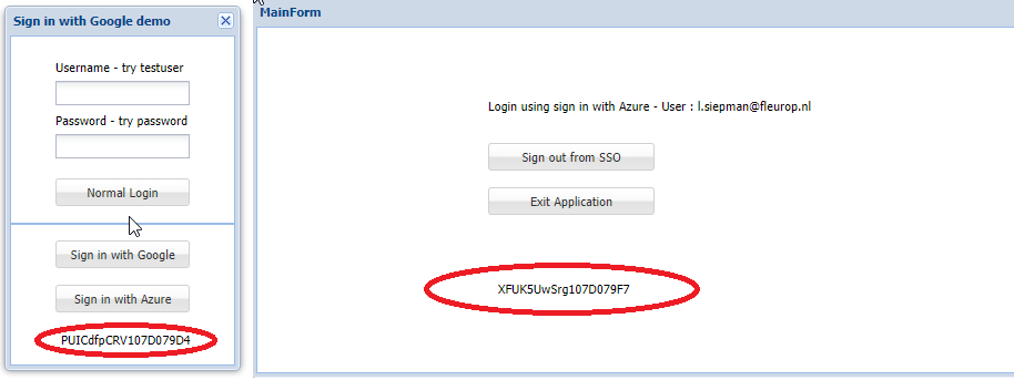
Just tried the Azure demo. It's a good starting point. I played with this a while ago and implemented it with javascript. I'm no very familiar with javascript possibilities (addjs...) and unigui. So at some point I got stucked. In the demo there is an issue when you login again after an succesful login. Then the callback situation is different.
-
-
Is the current Unigui version compatible or do we have to wait for an update?
-
Thx!
-
Just out of curiosity, was it possible to have more then 3 levels?
regards,
Leon
-
Hi Sherzod,
yes that was my intention.
regards
-
Hi Sherzod
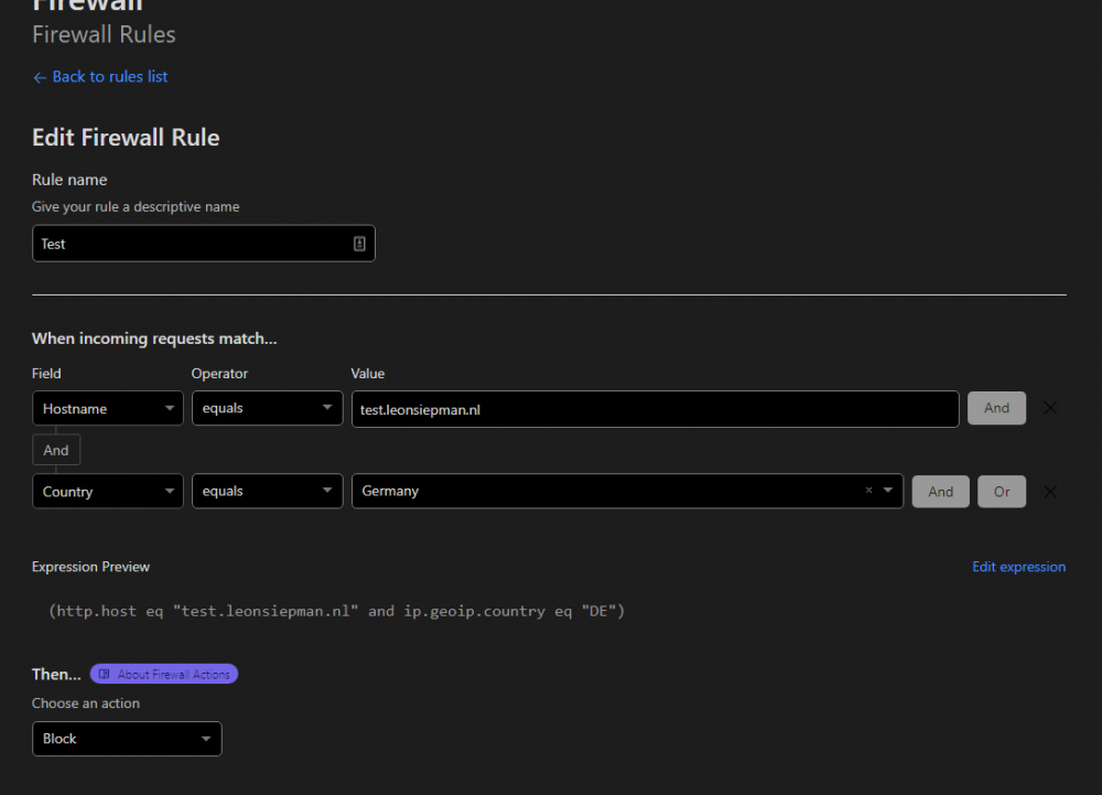
Thx for your answer. Just to be shure, BlockedIPList disables access to the full application, not only the /server option.
Regards
Leon
-
Hi
Is it possible to ignore the http;//xxapplicationxx/server based on an ip address? I want to allow the access to the server monitor from certain ipaddresses and ignore the other requests.
regards
leon
-
Hi
Is this possible to integrate with UniMap as Custom Maplayer? Targomo creates a layer on Maps.
https://targomo.com/developers/libraries/javascript/code_example/googlemaps_polygons/
Example HTML
<!DOCTYPE html>
<html><head>
<!-- Include google maps api -->
<script src="https://maps.googleapis.com/maps/api/js?v=3.exp&sensor=false&key=__your_google_api_key__"
type="text/javascript"></script>
<!-- Include targomo googlemaps full build -->
<script src="https://releases.targomo.com/googlemaps/latest-full.min.js" type="text/javascript"></script><style>
html,
body {
width: 100%;
height: 100%;
margin: 0;
}#map {
width: 100%;
height: calc(100% - 15px);
}#attribution {
width: 100%;
height: 15px;
}#attribution>a {
float: right;
font-size: 11px;
line-height: 15px;
padding: 0px 5px;
}
</style>
</head><body>
<!-- where the map will live -->
<div id="map"></div>
<div id="attribution"><a href='https://www.openstreetmap.org/copyright' target='_blank'>© OpenStreetMap contributors</a> <a href='https://targomo.com/developers/resources/attribution/' target='_blank'>© Targomo</a></div><script>
async function initMap() {
// create targomo client
const client = new tgm.TargomoClient('westcentraleurope', '__targomo_key_here__');// Coordinates to center the map
const myLatlng = new google.maps.LatLng(52.36, 4.88);// define the map
const map = new google.maps.Map(document.getElementById("map"), {
zoom: 11,
center: myLatlng,
mapTypeId: google.maps.MapTypeId.ROAD
});// init the first marker
const marker = new google.maps.Marker({
position: myLatlng,
map: map
});// polygons time rings
const travelTimes = [300, 600, 900, 1200, 1500, 1800];// you need to define some options for the polygon service
const options = {
travelType: 'bike',
travelEdgeWeights: travelTimes,
maxEdgeWeight: 1800,
edgeWeight: 'time',
serializer: 'json'
};// define the starting point
const sources = [{ id: 0, lat: myLatlng.lat(), lng: myLatlng.lng() }];// define the polygon overlay
const layer = new tgm.googlemaps.TgmGoogleMapsPolygonOverlay(map, {
strokeWidth: 20
});// get the polygons
const polygons = await client.polygons.fetch(sources, options);
// calculate bounding box for polygons
const bounds = polygons.getMaxBounds();
// add polygons to overlay
layer.setData(polygons);
// zoom to the polygon bounds
map.fitBounds(new google.maps.LatLngBounds(bounds.southWest, bounds.northEast), 0);
}google.maps.event.addDomListener(window, 'load', initMap);
</script>
</body></html>
Regards
Leon
-
1
-
Paging not working with ODBC driver
in General
Posted
Hi Sherzod,
In the VCL app it's working.
regards
Leon