lema
-
Posts
405 -
Joined
-
Last visited
-
Days Won
21
Content Type
Profiles
Forums
Events
Everything posted by lema
-
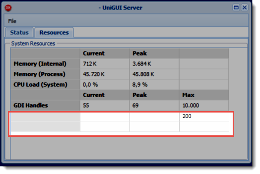
Hello, What is the '200' in the attached image? Delphi Seattle UniGUI ver 0.99.95.1298
-
Now I see that marker clusterer icons are gone. It's broken even on the main site's example pages https://googlemaps.github.io/js-marker-clusterer/docs/examples.html Probably Google removed the repository... There is a discussion about it on github https://github.com/googlemaps/js-marker-clusterer/issues I think we have to host the icons locally and change accordingly the library. icons.zip
-
Hello. At first, make sure that you have copied the js libraries under the directory /files (see the demo structure) Second, you will need an entry pointing to google api in your servermodule.CustomFiles. (http://maps.googleapis.com/maps/api/js?........) You can drop a gmap component on your main form and it will do the job for you. (You can set its visibility to false) And yes, you have to call at first the geocode procedure in order to get Latitude and Longitude and then use them in AddMarker.
-
Hi Peter. Can you provide a test app?
-
Hello, try the following UniGMapDXE7.zip
-
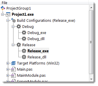
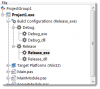
In Delphi 2010 that I was using for several years , I had no problem changing the target through the directive UNIGUI_VCL. The name in project manager was changing accordingly (Project.exe / Project.dll) , I had not even the need of closing and re-opening the whole project. Now, I evaluate the Seattle and the method of changing (commenting out) the compiler directive in project source doesn't seem to work for the project name showing in IDE - Project manager, even with closing and re-opening project and/or Delphi itself. For example , you see in the IDE that the target is the Project.dll , but the directive UNIGUI_VCL is active and the linker will link the project into the Project.exe. This will drive into misunderstandings. The workaround I use is the following . I create new configurations xxx_exe and xxx_dll I remove the {$define UNIGUI_VCL} from project source. In xxx_exe configurations, I add the UNIGUI_VCL in conditional defines and exe as Target file extension In xxx_dll configurations, I just change the Target file extension to dll Please correct me if there is any easier way to jump from library to program linking.
-
I agree. I have see the advantages of uniGUI over the 4-5 years of using the framework. My need for now is a very good presentation of uniGUI to the boss. I have to give my quotation and a project plan (and a small demo , I have already built). The whole plan must be competitive against web frameworks. So , if you have some points that I can focus, please post.
-
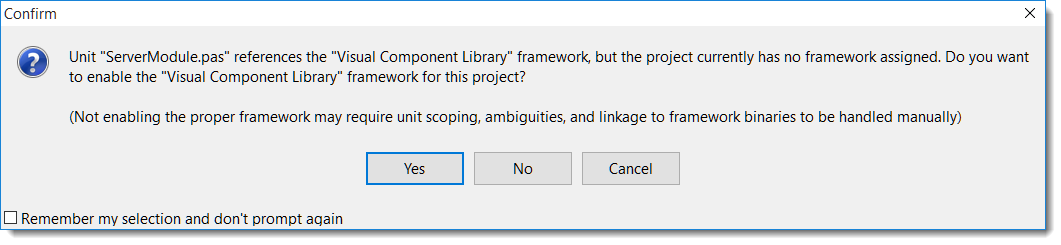
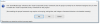
Hello, I am trying uniGUI under Delphi Seattle and every time , after creating a new project through Application Wizard (or mobile) I get the following message. Is it normal ? I am new to modern Delphi versions, so excuse me about the silly question. Win 10 Home Delphi Seattle uniGUI v0.99.95.1298
-
Hello, I am not sure that I understood your question. If you want to place a marker after the geolocation.getCurrentPosition call, you can see the demo's GeolocationAPIFM unit.
-
I want to retrieve latitude and longitude from geolocation from smartphone
lema replied to asapltda's topic in uniGUI Mobile
Does your device share its location ? Can you check it with another browser ? I tested successfuly on iphone and Samsung mobile with Android 4.1.2 Also change the UnimButton1Click : procedure TMainmForm.UnimButton1Click(Sender: TObject); begin UniSession.AddJS( 'if (navigator.geolocation) { ' + ' navigator.geolocation.getCurrentPosition( function(position) { ' + ' ajaxRequest(MainmForm.UnimButton1, "CurrentPosition" ,' + ' ["lat=" + position.coords.latitude, ' + ' "lng=" + position.coords.longitude, ' + ' "acc=" + position.coords.accuracy, ' + ' "alt=" + position.coords.altitude, ' + ' "altacc=" + position.coords.altitudeAccuracy, ' + ' "head=" + position.coords.heading, ' + ' "ts=" + position.coords.timestamp ' + ' ]);' + ' })' + '} else {alert("Geolocation is not supported.");}'); end; -
I want to retrieve latitude and longitude from geolocation from smartphone
lema replied to asapltda's topic in uniGUI Mobile
Hello, I am getting lat & lng with a simple geolocation.getCurrentPosition() mgeolocation.zip -
Hi , The company I work with is about to begin a new web project. The task is oriented towards CRM and must have web and mobile editions. There are some suggestions from web developers for frameworks that we can use. Unfortunately, as an old fashioned programmer, I know little about web frameworks and as a result I can't compare them to unigui. I would like your help concerning the suggestion I will need to make for unigui. What are the strong points that I can put forth? For example, Development time Security during deployment (code can't be stolen)
-
Did you try the demo app ? http://79.143.178.31/lema/uniGMapDemo.dll
-
Web application works asynchronous. As workaround you can use a timer with 100-200ms interval. procedure TForm1.FormShow(Sender: TObject); begin UniGMap1.InitializeMap; UniTimer1.Enabled := True; end; procedure TForm1.UniTimer1Timer(Sender: TObject); begin UniTimer1.Enabled := False; //Create Markers end;
-
Hello. try to place a gmap component on your Main Form. (you can set it invisible)
-
Wow. Currently , I am using the tdxmemdata in multi-threading environments (not only unigui) without problems. I thought, It was thread-safe ! Now I feel uncomfortable too...
-
Hello , I have been used the tdxmemdata in several projects. Extensive usage without any problem.
-
Hi, I also tested the demo with latest 1281. No problem on Firefox and Chrome.
-
There is a huge (and fast growing) new market around IOT. Over 5 million Raspberry boxes are sold till now. Farshad , please give it a try and save ourselves from python / php.
-
Hello. I don't have installed the Delphi XE4, but I think that the following code should be OK. package UniGMapDXE4; {$R *.res} {$ALIGN 8} {$ASSERTIONS ON} {$BOOLEVAL OFF} {$DEBUGINFO ON} {$EXTENDEDSYNTAX ON} {$IMPORTEDDATA ON} {$IOCHECKS ON} {$LOCALSYMBOLS ON} {$LONGSTRINGS ON} {$OPENSTRINGS ON} {$OPTIMIZATION ON} {$OVERFLOWCHECKS OFF} {$RANGECHECKS OFF} {$REFERENCEINFO ON} {$SAFEDIVIDE OFF} {$STACKFRAMES OFF} {$TYPEDADDRESS OFF} {$VARSTRINGCHECKS ON} {$WRITEABLECONST OFF} {$MINENUMSIZE 1} {$IMAGEBASE $400000} {$IMPLICITBUILD ON} requires rtl, vcl, vclimg, dbrtl, vcldb, uniGUI18, uIndy18, uniTools18; contains UniGMap in 'UniGMap.pas'; end.
-
Hello Renato. I don't think that we can have more accurate computation of distance than Google. But , if you want the full point list of each step , see the the UniDBGrid1CellClick procedure of DirectionsForm in demo project. If you iterate through these points you can calculate the progressive distance. You will also need the functions TUniGMap.DecodeLatLngPath and TUniGMap.ComputeDistanceBetween.
-
Hello Russell. As Alberto said in previous post, you have to rebuild the unigmap package. Also, make sure that you have completely uninstall any previous version (remove bpl / dcu files) before rebuilding.
-
Hello , Could you please attach a demo project to help me reproduce this issue?
-
Hi Renato. Now I see that you didn't include the required files /../files/uniGmap.css /../files/markerwithlabel_packed.js /../files/markerclusterer_compiled.js Please add them in the corresponding folder and try again.
-
Hello Renato. Yes , there is a problem. Please use the workaround with unitimer, until I find some time to look at it. edit: Included files was missing. See next post.