

Marlon Nardi
-
Posts
613 -
Joined
-
Last visited
-
Days Won
70
Content Type
Profiles
Forums
Events
Posts posted by Marlon Nardi
-
-
Simple sample:
procedure TUniMainModule.UniGUIMainModuleCreate(Sender: TObject); begin CDS.FileName := UniServerModule.StartPath + '\dados.dat'; CDS.CreateDataSet; CDS.LoadFromFile(CDS.FileName); CDS.Open; CDS.Insert; CDS.FieldByName('SessionID').AsString := UniSession.SessionId; CDS.FieldByName('IP').AsString := UniSession.RemoteIP;; CDS.Post; end; procedure TUniMainModule.UniGUIMainModuleDestroy(Sender: TObject); begin CDS.Locate('SessionID',UniSession.SessionId,[loCaseInsensitive]); CDS.First; while not CDS.Eof do CDS.Delete; end;-
 2
2
-
-
for now we have this.
http://www.unigui.com/resources/online-documentation/developer-manual
Sessions
"Another important difference from classical model is that in classical model your application is able to access all available session objects while in HyperServer each Node can only access sessions which are created by that specific Node. Needless to say that each Node holds a set of sessions which are isolated from other Nodes. If you need to query all of the sessions then you need to use different methods such as saving session information in a database table. You can simply create a row in the table when session is created and remove it when session is freed.
"
-
2
-
-
Hi @hph
download this example, it has the example you need.
-
 1
1
-
-
-
1
-
-
The Map Component is sold within the UniFalcon Package.
01] - FSiGrowl (Web e Mobile)
[02] - FSKendoUI (Web e Mobile) - Free
[03] - FSMask (Web) - Free
[04] - FSButton (Web)
[05] - FSMap (Web e Mobile)
[06] - FSColorPicker (Web)
[07] - FSEdit (Web)
[08] - FSToggle (Web e Mobile)
[09] - FSMenuButton (Web)
[10] - FSComboBox (Web) - Free
[11] - FSCalcEdit (Web) - Free
[12] - FSGoogleChart (Web e Mobile)
[13] - FSTheme (Web) (News Themes - Vulkan, Future and Crystal for new versions of UniGui )
[14] - FSToast (Web e Mobile)
[15] - FSConfirm (Web e Mobile)
[16] - FSPopup (Web)
[17] - FSQrCode (Web e Mobile) - Free
[18] - FSKeys (Web e Mobile)
[19] - FSMultiUpload (Web)
[20] - FSSignature (Web e Mobile)
https://store.falconsistemas.com.br
Sample application building with UniFSMap (Google Maps)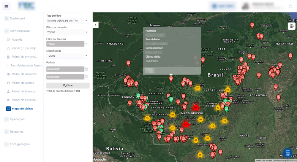
-
1
-
-
check your build directives in .dpr
{$define UNIGUI_VCL} // Comment out this line to turn this project into an ISAPI module {$ifndef UNIGUI_VCL} exports GetExtensionVersion, HttpExtensionProc, TerminateExtension; {$endif} -
Hi,
I'm having a problem.
I've been able to install the component without a problem.
When I create a small sample application, everything works just fine.
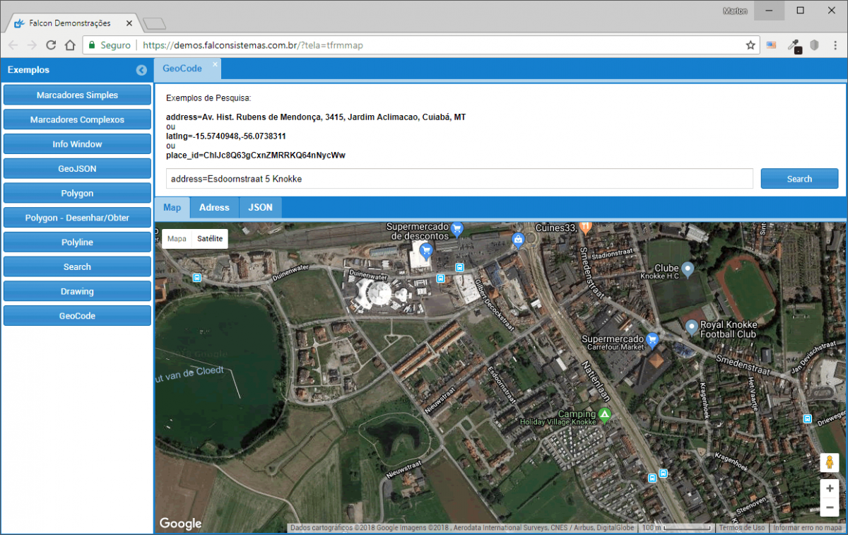
Now I'm trying to add it to an existing application and I get the following error when calling Geocoding:
Ajax error.
Google is not defined.
var geocoder = new google.maps.Geocoder(); geocoder.geocode({"address": "Esdoornstraat 5 Knokke"}, function(results, status) { if (status == google.maps.GeocoderStatus.OK) { ajaxRequest(O888, "Geocoder", ["lat="+results[0].geometry.location.lat(), "lng="+results[0].geometry.location.lng() ]); gm_O888.panTo( results[0].geometry.location ); } else { ajaxRequest(O888, "Geocoder", ["Geocoder failed due to: " + status]); } } );
Any idea?
Thx,
Dominique
Hi Dominique,In case you are interested you may be looking at my components:Store -> https://store.falconsistemas.com.br
-
Hi there...
Using XXX.1463 / Tokyo and noticed that in this particular example using your plug-in for a badge effect the button is cutting off the off-set badge's area as shown in the image.
It used to work in prior versions. Somthing due to the sencha Ex.JS version upgrade ?
Any tip or work around it ?
To solve add this
config.style={'overflow': 'visible'};
function beforeInit(sender) { config.style={'overflow': 'visible'}; sender.action = 'badgetext'; sender.plugins = [ { ptype:'badgetext', defaultText: 10, disableOpacity:1, disableBg: 'green', align:'right' } ]; }-
1
-
-
Example:
add -> ClientsEvents -> ExtEvents -> afterrender
Ext.create('Ext.tip.ToolTip', { target: sender.getEl(), html: "My Tooltip!" }); -
with the new version of uniGUI?
-
Hi
To resolve, uninstall the package:
Delphi
Component -> Install -> Package, Locate the package and remove.
After that install uniGui again and then the falcon package.
any doubt call me on skype: marlonnardi
-
If it helps.
-
Selecione o TUnimPanel ->
LayoutConfig -> Height -> 100%
-
1
-
-
Great job, congratulations!
Similar to a theme I did at the time, uni-butterfly, but yours is more beautiful

-
-
-
.x-tab-bar-default {

    background-color: #ff000000 !important;

} -
This is interesting!

-
Yes, I also had this experience, there is a lot in CSS and classes that have changed.
Another thing on your screen NEW: 0.99.96.1330? -
Excellent, it follows one more facilitator for installation of the same
-
2
-
-
Olá Flavio,
Isso é bem simples, você pode esta utilizando este projeto de demonstração para entender:
C:\Program Files (x86)\FMSoft\Framework\uniGUI\Demos\Desktop\URLParameters
-
Yes,
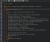
Let's do by stages, due to the weather,I'm going to do a little project in Android Studio and share it on gitHub.with the @JavascriptInterface interface classeswith this interface you can communicate natively with javascript and Android: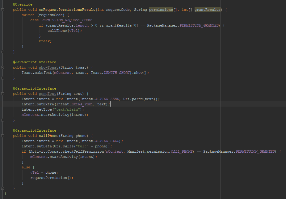 and unigui:
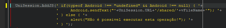
-
1
-
-
Hi,
I did in Android Studio + uniGUIhttps://play.google.com/store/apps/details?id=br.com.falconsistemas.financas
and
Xcode + uniGUI
https://itunes.apple.com/us/app/icb-c%C3%A9lula/id1307712423?mt=8
It was very good. -
Or
https://store.falconsistemas.com.br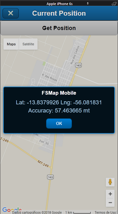
Simple Code:
procedure TfrmCurrentPosition.btnGetCurrentPositionClick(Sender: TObject);
begin
  map.GetCurrentPosition;
end;

procedure TfrmCurrentPosition.mapAjaxEvent(Sender: TComponent;
  EventName: string; Params: TUniStrings);
begin
  if EventName = 'fs_get_current_position' then
  begin
    if Params['status_geo'].Value = 'denied' then
      ShowMessage('Access coordinates permission denied');

    if Params['status_geo'].Value = 'enabled' then
    begin
      ShowMessage('Lat: '+Params['lat'].Value+' Lng: '+Params['lng'].Value+' Accuracy: '+ Params['accuracy'].Value+' mt');

      map.SetCenter(Params['lat'].Value, Params['lng'].Value);
    end;
  end;
end;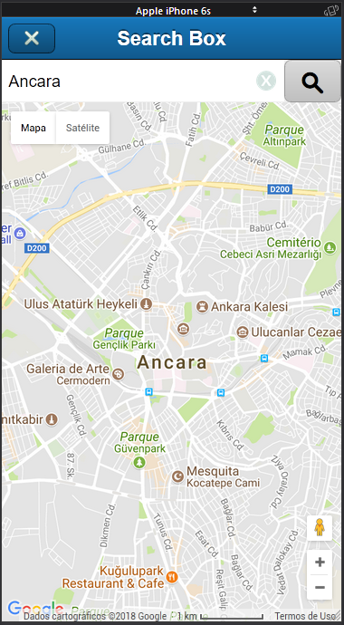
procedure TfrmSearchBox.btnSearchClick(Sender: TObject);
begin
  map.SearchBox(edtSearch.Text);
end;

procedure TfrmSearchBox.mapAjaxEvent(Sender: TComponent; EventName: string;
  Params: TUniStrings);
begin
  if EventName = 'fs_map_geocoder' then
  begin
    if Params.Values['notfound'] <> EmptyStr then
    begin
      ShowMessage(Params.Values['notfound']);
      Exit;
    end
    else
    begin
      map.SetCenter(Params.Values['lat'], Params.Values['lng']);
      map.SetZoom(13);
    end;
  end;
end;


How do I get all the active sections in Hyper Server?
in General
Posted
Exactly, I did just to get an idea of what it would be like, the CDS would be the DB (example)